The purpose of this guide is to inform Littleton residents of the various and unique properties available to them for walking, nature study, picnicking, and other forms of recreation in nature. Some of the Littleton conservation properties are well established and maintained. Others are new and being improved by volunteer Land Stewards who upgrade them and provide consistent maintenance. The Boy Scouts also offer their skills in the care of our public lands by constructing trails and footbridges.
Each of the lands described in this guide is administered by one of the following town organizations:
- Littleton Board of Selectmen (BOS) – The town’s elected, governing officials.
- Littleton Conservation Commission (LCC) – A town board whose members are appointed by the Board of Selectmen. The LCC administers the Wetlands Protection Act and acquires conservation land.
- Littleton Conservation Trust (LCT) – A private, nonprofit conservation organization that performs environmental, educational, and land stewardship activities. The LCT also owns conservation land for the benefit of the Town of Littleton.
Note: You can purchase a hardcopy edition of the Littleton Conservation Land guide. Copies are available via the LCT or at the Reuben Hoar Library in Littleton for $10.00 .
Download the Trail Guide
A downloadable PDF Trail Guide is available here: https://littletonconservationtrust.org/Trail_Guide.pdf
Locator Map and Property List

Size: 7.2 acres
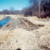
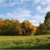
This property is pie-shaped with 340 feet of frontage on King Street extending northerly about 1000 feet. Most of the land is wet meadow with a brook flowing through the center of the property. The east side, bordering on the Castle-in-the-Trees playground, is dense woodland with very old trees and abandoned farmland.
Note that this trail is not accessible most of the time. Animal trails are abundant with evidence of beaver and deer but it is difficult to get in to see them except during very dry times.
Size: 23.67 acres

Size: 15.5 acres

Size: 6.7 acres
A well-developed trail starts at the entrance and proceeds through the grove to a board walk that crosses the swamp. The boardwalk, provided largely through efforts of high school students under the leadership of science teacher, Betty Leonard, provides a close up look at swamp vegetation and wildlife, including birds, frogs, tall reed grass, red maples, wild cherries, and skunk cabbage. Use of the trail for nature study is encouraged.
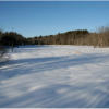
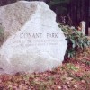
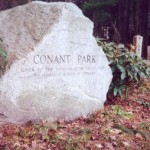
The Two Brothers Trail starts at the Park entrance and proceeds through the center of the park going off site to the rear of the parking lot behind the town offices.


Size: 53.6 acres

Size: 87 acres
The Town of Littleton purchased 87 acres of land from the Hartwell family in 2003 for conservation purposes. The land abuts protected Water Department land consisting of 14.7 acres and 3.5 acres of land belonging to the Littleton Conservation Trust, for a total of about 102 acres.
Activities: Birding, Hiking/Walking, Wildlife Viewing


Size: 4 acres
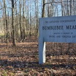
Jones Meadow is an open meadow with a small area of woods.
The conservation commission will hold the conservation restriction on the property, with the intent of keeping it in its natural and open state with mown paths for walking and wildlife observation.
Activities: Birding, Hiking/Walking, Wildlife Viewing

Size: 180 acres
Longest walk:
1.82 miles
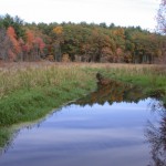
The site rises gradually from Newtown Road with an elevation of about 260 feet to the hilltop, midway to the rear where the elevation is about 360 feet. From this hilltop, the site slopes downward toward the north with the northerly property line being Long Lake.
Adjacent to the acquired land on the west side are 75 acres of existing conservation land. This land has been acquired through the years by gifts or tax foreclosures. It includes several thousand feet of undeveloped shoreline of Long Lake and the lake's outflow brook. This land is now administered under this same management plan for the acquired Long Lake Conservation Land. This creates 180 acres of conservation land.
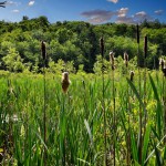
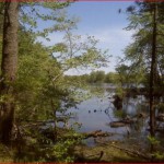
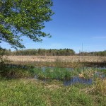
Long Lake Park hosts a wide variety of natural habitats including bordering vegetated wetlands, forested wetlands, conifers, hardwoods, grasslands, and edge habitat.
The southernmost portion of the parcel consists of a wet meadow which contains a stream, a vernal pool, and an upland meadow. This area extends several hundred feet north along the eastern half of the property, eventually giving way to a very thick briar patch and a red maple wetland. This wetland continues north for several hundred more feet, decreasing in width, until it ends in a narrow "finger". Here originates the apparently spring-fed stream which flows to Newtown Road. To the east of the "finger" is a mixed hardwood forest of maple, oak, and ash, while to the west is located a several decades old white pine forest. Both forests continue north to the AT&T easement, the area north of that appearing to have been logged in the past and consisting of scattered red pine, white pine, and hardwood species, all of varying degrees of maturity. In the extreme northwest corner is a small hemlock grove and a portion of an unusual wet bottom forest actually growing in the shoreline waters of Long Lake.
Activities: Birding, Hiking/Walking, Wildlife Viewing

Size: 20.3 acres
Longest walk:
1 mile
Mary Shepherd Conservation Land features a one-mile trail through woodlands and a meadow within 20.3 acres of town-owned land.
Follow the white markers between the houses at Snow Terrace. The area may look like a yard, but it is town property. The trail follows a forested ridge (called a glacial esker) easterly toward the Westford town line. The trail proceeds northerly down the side of the ridge to an old farm road, which leads to the open field. The trail makes a circular route (follow the worn area in the grasses) around the rear of the new homes to a wet part of the field and into woodlands to a brook. A footbridge crosses the brook. The trail then proceeds up hill to the top of the hill where a parking area is located off Powers Road.
Activities: Birding, Hiking/Walking, Wildlife Viewing

Size: 24.4 acres
The Mill Hill property is part of the Beaver Brook green belt. The land, partly wooded and partly cleared, rises from Beaver Brook to the top of the hill.
The trails pass through mature oak woodlands. Beaver Brook borders the area but is difficult to reach because of thick undergrowth. The land is not well known and shows little use. Unfortunately, the noise level is very high from nearby Route I-495.
Activities: Hiking/Walking, Picnicking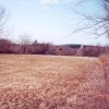

Size: 50 acres

Size: 129 acres
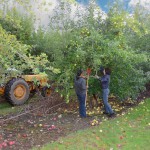
83 acres that include the orchard and buildings (with the exception of the house formerly owned by Mrs. Morrison) are leased to Nagog Hill Fruiters. The remaining acreage is conservation land split between two parcels (note that the orchard is restricted – it is not land that is open for the public’s use):
The Nagog Hill Road parcel is the area below the former Morrsion home and the small orchard. This is a southeasterly facing slope that has been mowed for many years. It is bounded by Nagog Hill Road to the east; Mrs. Morrison’s lot to the north, west is the tree line, and a small apple orchard to the south. Along the road frontage there is a stone wall with red oaks and poison ivy. The slope has an even, gentle grade and is covered primarily with grasses. The grasses are invaded with violets, hawkweed, crow's foot, everlasting and mullein. The tree line includes red pasture juniper, red maple, black birch; walnut, rose, wild strawberry, blueberry, barberry, rattlesnake plantain, poison ivy and rhododendron.
A second parcel (Nashoba Road) is a wooded slope across from the entrance to Sarah Doublet Forest. This is a west facing slope with a wet swale along the road frontage. A stone wall bisects the wooded area. Trees include hemlock, elm, white birch, black birch, hickory, red maple, white pine, red oak and beech. The under story growth is dominated by saplings of the tree cover. Shrubs observed are raspberry, blackberry, poison ivy (covering many of the trees), bittersweet (several large growths covering the trees), honeysuckle, barberry, dogwood and rose. Herbaceous layer shows horsetails, skunk cabbage, sensitive fern, cinnamon fem, lady fem, poison ivy and Canada mayflower. This larger parcel is exceptionally important, as it provides habitat and a safe migration corridor for the diverse mammal population. This wooded parcel, which is threaded by numerous small drainages from the orchard, is itself a vibrant and valuable "edge"' habitat, because it is bordered on one side by orchard. A connector trail starts from Nashoba Road across the road from the Sarah Doublet Forest Road and passes through the parcel to Nagog Hill Road and then connects to the blue dot trail on the detached parcel.
Activities: Birding

Size: 25 acres
Approximately 1 to 2 acres of this land is forest, with the remainder being a mature wooded swamp. A small narrow inaccessible pond (about 1 acre) occurs along the western edge of the property. The forested acreage consists of a 500 feet long peninsula perpendicular to Nashoba Road. The land surface of the peninsula rises as high as 7 to 8 feet above the surrounding swamp. Vegetation species observed in 1998 include:
Wooded Swamp: Oaks, red maple, sweet pepperbush, ferns, high bush blueberry, mosses, and button bush.
Forested Peninsula: Beech, oak, red maple, black birch, witch hazel, and tea berry.
The forested peninsula provides an excellent opportunity to penetrate deep into the center of an extensive mature wooded swamp without struggling through muck, water and hummocks. The swamp contains large Maple, and Oak trees with an understory of Sweet Pepperbush, blueberry, mosses and ferns. The trail provides good opportunities to observe swamp wildlife and vegetation species.
Activities: Hiking/Walking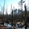

Size: 100 acres
Nashoba Woodlands encompasses the trails within and connecting Cobb Trail, Cobb Forest, George and Lucy Yapp Conservation Land, Morrison Orchard Extension, Fort Rock and Shaker Lane School Land. It is possible to enter from any of these areas and hike to / through the others.
Activities: Birding, Hiking/Walking, Wildlife Viewing
Size: 98 acres
Newtown Hill conservation land offers an opportunity to enjoy nearly 100 acres of variety. As you begin to climb the paved access road, your eye is drawn upward across the rolling meadows to watch a broadwing hawk soaring and searching for food. On the right, grape vines and bittersweet nearly hide an old stone wall, the first of many surrounding the property. Daisies, Queen Ann's lace, Indian paint brush, clover, milkweed, butter-and-eggs, black-eyed Susans: the pages of your wildflower book will move as fast as those of the birder's 'Peterson'.
When you reach the large boulder near the crest, sit awhile and enjoy the view eastward. On a clear day Boston's skyline rises straight ahead. Rested, begin to descend toward the old apple trees on the right and continue onto the dirt road which leads you through the woods to the second meadow and a sylvan treat: a magnificent specimen beech tree - friend of lovers for generations, if you believe the carvings. Please don't add to them.
In the spring time, as you leave the beech grove you may glimpse below through the trees the flooded meadow. This is a quaking peat bog and a refuge for migrating Canada geese and duck of several species. The meadow dries to a small pond in summer and tall grasses grow to invite the migrants on their fall return. The woods surrounding you are part of the Town Land but no trails have been cut. Pine, hemlock, ash, maple, birch and other trees grow by natural selection.
This land has always been useful to man - a meeting place, a look-out, a hidden spring, a fort, an apple orchard: each in its turn. Now under the management of the Conservation Commission, the meadow is hayed in summer by a local farmer, and skied on by hardy enthusiasts in the winter.
Activities: Birding, Hiking/Walking, Wildlife Viewing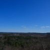
Size: 220 acres
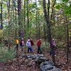
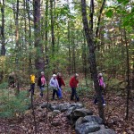
Oak Hill is a place to stretch your legs and mind as you walk its trails. This parcel is comprised primarily of oak woodlands with many trails - some of which are old.
Interesting Features - Look for the following features of interest:
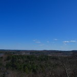
Lookout Rock - 475 feet high, this rock provides a view towards the south and southeast. A joint LCT / LCC undertaking in 2011-2012, in which 28 tall trees were removed below the cliff, has reopened this scenic vista giving panoramic views. One can easily pick out the John Hancock and Prudential Tower buildings on the horizon on a clear day (26.5 miles away, compass heading 118° True).
Tophet Chasm - A temporary outlet carved out of rock for an extensive glacial lake about 15,000 years ago. Oak Hill is the northern tip of a long ridge of hills called Shrewsbury Ridge by geologists. In glacial times, the ridge acted as the eastern shore of a vast glacial lake, Lake Nashua. Its northern shore was the face of the melting glacier. At one stage late in the history of the lake, the water found an eastern outlet through a low weak fault area on Oak Hill. Here the rushing stream fell to carve a deep chasm. The head of the chasm was an ancient waterfall 120 feet high, only 38 feet less than the mighty Niagara’s 158 foot drop. Today the falls are silent and the debris of the ages has filled part of the chasm floor so that the walls rise a somewhat lesser 80 feet – still enough to be impressive. The floor of the chasm contains a swampy area, known as Tophet Swamp. This quiet swamp, surrounded by steep bedrock cliffs, abounds in wildlife and vegetation. Dominant species include red maple, high-bush blueberry, hemlocks, black birch, ferns, and a sphagnum moss mat. (Tophet is an old term for “hell” or “place of fire.”)
For more information about Oak Hill, see the Natural Resource Inventory for Oak Hill-Tophet Chasm that was prepared in November 1987 and updated in 1998. Copies of the inventory are available at the Reuben Hoar Library and at the Conservation Commission office in the Town Offices.
Activities: Hiking/Walking, Wildlife Viewing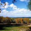

Size: 107 acres
Prouty Woods is a unique and significant tract of woodland within minutes of Route 495. The property includes 1600 feet of frontage on Long Lake and the top of Wilderness Hill with expansive views to the west and north including Mount Monadnock. The combination of forest, hay fields and riparian zones provide much-needed habitat for a variety of species. The forest has been under professional forest management for many years. Walking trails maintained by Stewards of the Littleton Conservation Trust (LCT) connect to a one-mile trail called the Two Brothers trail that extends to Conant Park. The main house serves as the headquarters for the New England Forestry Foundation (NEFF). The Wilderness House (King Center) situated on top of Wilderness Hill hosts educational programs that promote an understanding of forestry and the natural world.
Activities: Hiking/Walking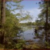
Size: 47 acres
The Robert and Emily Cobb Memorial Trail parcel provides a variety of features within a relatively small area. The land is quite different from other conservation areas in Littleton.
Extends in a linear pattern from the Pickard Lane Extension on the north, by Cobb's Pond on the east, to Nashoba Road on the South. It abuts the 30 acre town owned Nagog Hill Orchard extension on the west.
Note: The trustees of Emily R. Cobb did not grant use of Cobb's Pond to the public.
A peninsula extending into Cobb's Pond is owned by the Town and is under the management of the Littleton Conservation Commission and Littleton Water Department. Another recently acquired section is owned by the Town and managed by the Littleton Conservation Trust for the Littleton Conservation Commission.
Activities: Hiking/Walking, Wildlife Viewing

Size: 61 acres
SVT and the Town of Harvard share ownership of these stunning properties that provide essential habitat for numerous species of wildlife. With help from private donors, SVT purchased the 48 acres in Littleton, while the Town of Harvard purchased the 12 acres in Harvard. The Littleton Conservation Trust holds a conservation restriction over all 60 acres.
With a new parking area on Whitcomb Avenue in Littleton, and trail loops now open on both sides of the road, Smith Conservation Land boasts expansive views of both Beaver Brook Marsh and Black Pond Ravine.
Please note: Dog walking is allowed, however dogs must be on a leash.
Activities: Birding, Hiking/Walking, Wildlife Viewing
This trail begins at Conant Park. It is 1.5 miles long (about a 45 minute walk). After following the trail for a while you can see a boardwalk on the right. The boardwalk leads to the Russell Street School and the track area. When you continue on the trail, you cross an old fire road. Cross over the fire road to stay on the trail. In a few minutes the trail takes a sharp left. Follow the trail to the left and you see a flight of stairs. When you reach the top of the stairs, you are at the parking lot behind the town offices.
Walk to King Street and turn right down the sidewalk until you reach the Congregational Church. Across from the church, you can see a sign for Two Brothers Trail. (This parcel of land is known as the Morgan Land.) Cross the street and follow the old dirt road to the field. Once in the field, follow the trail along the stone wall until you reach the edge of the forest. You might be lucky enough to see a red-tailed hawk circling overhead.
As you enter the forest, you cross a stone wall that signifies the end of the Morgan Land and the beginning of the Prouty Woods Community Forest, a 107 acre forest owned and maintained by the New England Forestry Foundation (NEFF). Follow the Conservation Trust markers to the top of the hill down to the Long Lake shore. At trail intersections, there are 4x4 wooden posts giving directions.
Following the direction of the sign post, continue on the trail as it goes up to the top of Wilderness Hill. From there, the trail proceeds down the hill to the shore of Long Lake.
Activities: Birding, Hiking/Walking, Wildlife Viewing
Size: 32.25 acres