Oak Hill
Overview
Oak Hill is a place to stretch your legs and mind as you walk its trails. This parcel is comprised primarily of oak woodlands with many trails – some of which are old.
Interesting Features – Look for the following features of interest:
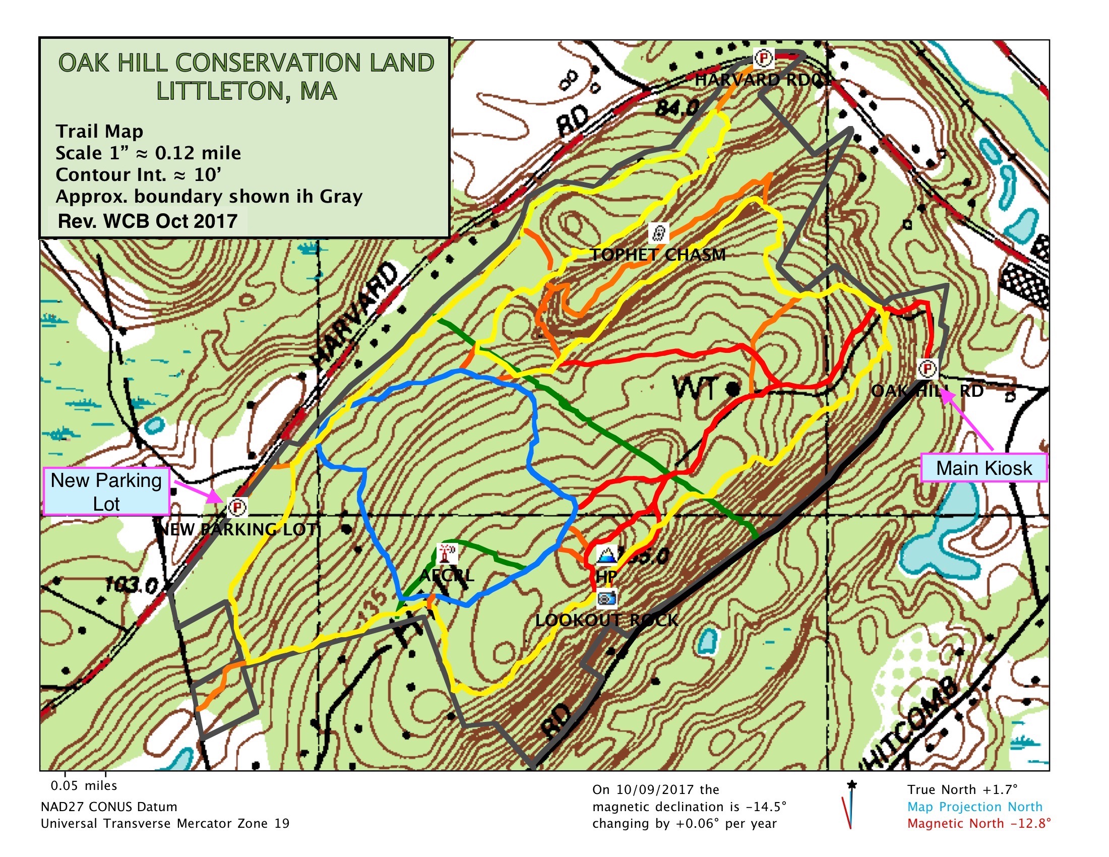
Lookout Rock – 475 feet high, this rock provides a view towards the south and southeast. A joint LCT / LCC undertaking in 2011-2012, in which 28 tall trees were removed below the cliff, has reopened this scenic vista giving panoramic views. One can easily pick out the John Hancock and Prudential Tower buildings on the horizon on a clear day (26.5 miles away, compass heading 118° True).
Tophet Chasm – A temporary outlet carved out of rock for an extensive glacial lake about 15,000 years ago. Oak Hill is the northern tip of a long ridge of hills called Shrewsbury Ridge by geologists. In glacial times, the ridge acted as the eastern shore of a vast glacial lake, Lake Nashua. Its northern shore was the face of the melting glacier. At one stage late in the history of the lake, the water found an eastern outlet through a low weak fault area on Oak Hill. Here the rushing stream fell to carve a deep chasm. The head of the chasm was an ancient waterfall 120 feet high, only 38 feet less than the mighty Niagara’s 158 foot drop. Today the falls are silent and the debris of the ages has filled part of the chasm floor so that the walls rise a somewhat lesser 80 feet – still enough to be impressive. The floor of the chasm contains a swampy area, known as Tophet Swamp. This quiet swamp, surrounded by steep bedrock cliffs, abounds in wildlife and vegetation. Dominant species include red maple, high-bush blueberry, hemlocks, black birch, ferns, and a sphagnum moss mat. (Tophet is an old term for “hell” or “place of fire.”)
Historic stagecoach roads – Two stagecoach lines crossed Oak Hill in the 1830s. The one from Acton entered Oak Hill at the present main entrance, skirted the hill just below the standpipe and met the Lowell-Worcester route, which ran parallel to Harvard Road. They are now part of the hiking trails. You can note the grooves in boulders and ledges worn by the iron-bound wheels of the heavy coaches.
Oak Hill Electronics Laboratory – The US Government leased property here from 1958 to 1964. An Air Force Cambridge Research Laboratory (AFCRL) receiving station used in radio propagation research was located inside the chain link fenced area off Fire Road 1. Nearby there are two sets of concrete piers that must have supported antenna towers.
For more information about Oak Hill, see the Natural Resource Inventory for Oak Hill-Tophet Chasm that was prepared in November 1987 and updated in 1998. Copies of the inventory are available at the Reuben Hoar Library and at the Conservation Commission office in the Town Offices.
The Town of Littleton purchased this land for conservation, recognizing its unique natural features. The property, much of it purchased from the Sanderson and Willett families, was approved for purchase on January 25, 1971 following approval by Town Meeting. A Land and Water Conservation Fund grant was awarded in February 1971 for $33,000 in partnership for this purchase. The Town of Littleton has a water tower near the top of the hill. A telecommunication tower is located adjacent to the water tower.
Trails
Approximately seven miles of trails, last remarked in 2010. There are three principal trails marked red, yellow, and blue, 1.1 miles of orange marked link trails, and 0.8 miles of unmarked trails.
Summit trail (red markers) - Starts at the main entrance (parking lot/kiosk) and brings you up to Lookout Rock (0.7 miles, 200' climbing). After passing by Lookout Rock, the trail continues up to the vicinity of the highest point in Littleton (508') and circles back down to re-join the main trail (0.15 miles). Two spurs are now marked and have signs: one that leaves the main trail below the water tower (0.3 miles long), and a short spur that connects to the Interior Loop Trail (0.1 miles).
Features include bedrock, wagon wheel grooves worn into the rock (see History), a spring, mountain laurel thickets (blooms in May/June), and a beech tree grove. Scattered sassafras and American chestnut sprouts on the way to Lookout Rock. The bedrock schist rock is more than 900 million years old.
Boundary trail (yellow markers) - This loop trail is the longest trail on the property and starts 0.1 miles from the main entrance where there is a sign. Followed in a counter-clockwise direction, the trail takes you over to and along the south edge of Tophet Chasm; out to the AT&T easement; back to and along the north side of Tophet Chasm (new section of trail blazed in 2010); follows an old stage coach road; and the perimeter of the property to Lookout Rock and back to the starting point (3.3 miles, 420' climbing).
Features include fine groves of gray birch and eastern hemlock as well as thickets of mountain laurel, and four significant erratic boulders.
Interior Loop (blue markers) - A woodland trail on the north facing side of the hill (1.0 miles, 150' climbing) that can be accessed directly or by links from the Summit Trail or Boundary Trail. This trail has an interesting 'natural arch' tree that is a remnant of the December 2008 ice storm.
Link Trails (orange markers) - These short trails, which range from 0.02 miles to 0.4 miles in length, are generally used to connect one principal trail to another. There are two links off the stagecoach portion of the Boundary Trail which both go out to Harvard Road (Note that there is parking space for two vehicles near the gated/signed entrance on the north-east side of the property). There is a steep link near the head of Tophet Chasm that connects the Boundary Trail. The original Tophet Chasm Trail, which had not been maintained since the late 1980's, was cleared and improved as an Eagle Scout Service Project in 2014. This 0.4 mile challenging link gets one down to the dramatic floor of the chasm/swamp, and also connects the Boundary Trail. There is a short link in the SW corner of the property that connects to the 8.1 acre Plante Tax Title Conservation Land in Harvard, which contains a scenic small pond.
Unmarked Trails (no markers, but shown in green on the accompanying map) – There are two major unmarked trails. The AT&T easement trail (0.5 mile), where an underground fiber optic cable crosses the property from Oak Hill Road to Harvard Road, was once the route of the Transcontinental Cable. The other trail is part of Fire Road 1 that goes by the defunct AFCRL site (see Interesting Features).
Directions
Near Littleton Depot, 1/2 mile from the junctions of Route 2 and 495. Main parking area and entrance is off Oak Hill Road. New 10 car lot opened on Harvard Rd. in Sept. 2017.