Robert and Emily Cobb Memorial Forest
Overview
The Robert and Emily Cobb Memorial Trail parcel provides a variety of features within a relatively small area. The land is quite different from other conservation areas in Littleton.
Extends in a linear pattern from the Pickard Lane Extension on the north, by Cobb’s Pond on the east, to Nashoba Road on the South. It abuts the 30 acre town owned Nagog Hill Orchard extension on the west.
Note: The trustees of Emily R. Cobb did not grant use of Cobb’s Pond to the public.
A peninsula extending into Cobb’s Pond is owned by the Town and is under the management of the Littleton Conservation Commission and Littleton Water Department. Another recently acquired section is owned by the Town and managed by the Littleton Conservation Trust for the Littleton Conservation Commission.
Trails
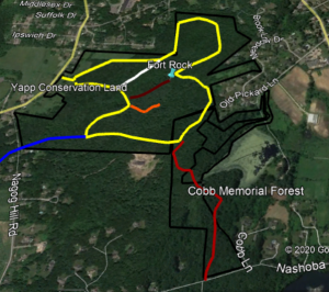
The Cobb Memorial Trail extends 0.7 miles from Pickard Lane extension to Nashoba Road. The trail mostly follows an old cart road. Brown and white signs saying "Cobb Memorial Footpath" are located at each end of the trail which is indicated in the field with red markers. The foot path connects to the "Blue Dot Trail" which leads westerly to Nagog Hill Road, a distance of 0.5 miles. A nearly 100 foot long boardwalk over a swamp is located near the Nashoba Road entrance. This boardwalk was an Eagle Scout project.
Near the Pickard Lane parking area is a trail that connects to the trails in the Yapp Conservation Land and also to Shaker Lane.
Directions
Located at a small gravel parking lot on Nashoba Road and within the cul-de-sac at Pickard Lane Extension.


