Hartwell Family Memorial Preserve
Overview
The Town of Littleton purchased 87 acres of land from the Hartwell family in 2003 for conservation purposes. The land abuts protected Water Department land consisting of 14.7 acres and 3.5 acres of land belonging to the Littleton Conservation Trust, for a total of about 102 acres.
Notable Features:
The Hartwell land has a wide variety of natural and man-made features within a relatively small area:
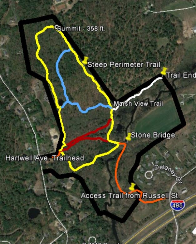
Beaver Brook – The largest and longest brook in town, Beaver Brook starts in Harvard and flows into Westford. It provides an important water supply aquifer for Littleton.
Old Stone Slab Bridge over Beaver Brook – This bridge is probably 150 years or more old. It is on an old carriage road that led to Ayer.
Agricultural Field – Formerly used for crops, currently mowed annually.
Pocket Meadows – Small grasslands enclosed by woodland.
Woodland – Second growth and mature oak and hickory dominant forest with some pines, black birch, and hemlocks. One large, relatively rare basswood tree is just off the Loop Trail.
Marsh – Excellent bird habitat adjacent to Beaver brook.
Steep Hillside – Woodland on southwest side of Proctor Hill, 100 feet difference in elevation.
Swamp – Densely wooded swamp with old drainage ditches.
Dam and Pond – Small man-made pond and dam on Loop Trail, showing recent beaver activity.
Esker – A glacial feature. Long narrow wooded ridge of sand and gravel formed in a pre-existing12000-year-old glacial meltwater channel.
Wildlife – There is habitat for a variety of birds and animals, including beaver, deer, wild turkeys, and fishers.
Trails
Numerous, well-developed main trails, as well as side trails.
A marked red loop trail starts on a ridge adjacent to the parking lot near a yellow gate. The Loop Trail makes a circle through the land and returns to the parking lot, which is a leisurely half-hour walk. There are numerous smaller side trails and old roads in the property that have been there for many years before town acquisition. An unfinished but passable trail starts at the right hand side of the stone bridge across Beaver Brook and proceeds all the way to Russell Street through Town and Town Water Dept. land. A very steep unmarked trail goes up the side of Proctor Hill, but it is difficult walking. Property lines (where firmly identified) have been marked by aluminum discs with Conservation Commission logo. Other property lines (not yet laid out by survey) are unmarked.
Directions
Off Hartwell Avenue, about six tenths of a mile from Route 2A (Ayer Road). The land is located on the East Side of the street, opposite utility pole number 71.
Parking is behind a green and white sign saying “Hartwell Family Memorial Preserve” Enter between two posts (old utility poles) and park in the grassed area.